White chalk cliffs on the coast of the strait do not look in vain as if they were cut off with a knife
Britain became an island due to a powerful natural disaster that occurred 200 thousand years ago. This was established by Sanzheev Gupta and his colleagues from Imperial College London.
Evidence of the disaster received in the course of geological surveys. At the bottom of the canal separating Britain from the mainland, a high-resolution sound location revealed “deep scars” that were once produced by a sudden release of a colossal volume of water. In the same place, “land” relief details were found, clearly cut by powerful streams of water, and even the channels flowed even earlier on the surface of rivers.
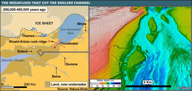
This water came from a huge lake on the site of the current North Sea, blocked in that era by ice. The lake was fueled by thawed glacial water from the ancient Thames and the Rhine, which have since changed their routes.
To the south of this large body of water, Britain connected to mainland Europe. But once a powerful earthquake destroyed an ice dam in the area of the current Dover Strait, and a stream of water rushed south, cutting its way even through the mountains.
The latter, however, is explained by the fact that they were composed of chalk, and above the present sea level this ridge rose only 30 meters.
Dr. Gupta claims that this water discharge was one of the brightest mega-floods in history, and it was to him that Britain owed its island status.
“If this did not happen, then Britain would always be the peninsula of Europe. There would be no need for a tunnel under the English Channel, and you could always get from France to the UK on dry land, as the early people did before the flood,” explains scientist.
People settled Britain on the eighth attempt.
The mega-flood lasted several months, releasing from the lake about one million cubic meters of water per second.
Researchers emphasize that although the theory of such a flood in the area has existed for 30 years, for the first time it has been possible to obtain clear evidence of this event, a kind of record in stone.
Britain and France 200 – 450 thousand years ago. The land that remains after the flood is shown in yellow; light beige – the territory covered at that time by a glacier; brown – areas now under water; the red arrow indicates the direction of the flow through the dam; blue color – glacial lake, light blue – Atlantic. 1 – Veld-Artois ridge. Rivers: 2 – Thames, 3 – Rhine, 4 – Somme, 5 – Seine, 6 – Solent.
The bottom of the English Channel, formed by a catastrophic flood. Color scale – depth in meters. The area shown here on the previous map is marked with a white rectangle.
This post is also available in:
 English
  Русский (Russian)


